
Oil and Gas
TROVE database


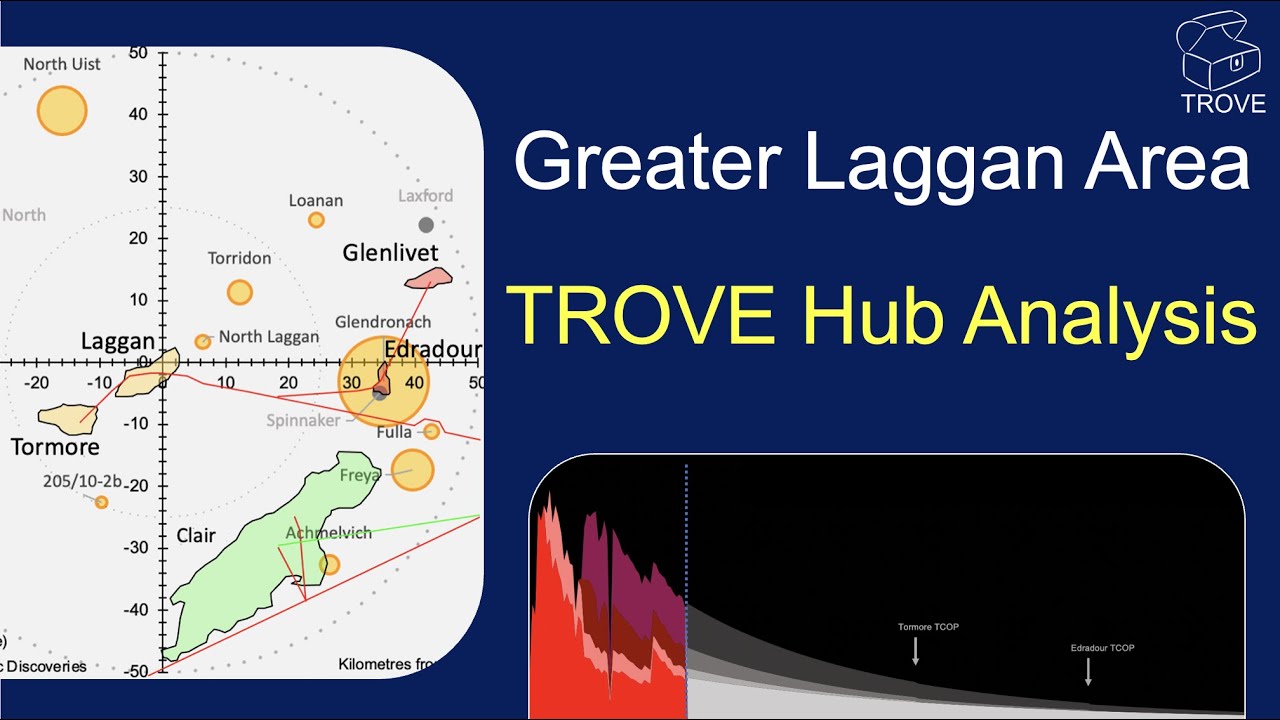
These borderless basin-wide subsurface technical databases have involved decades of research and input sourcing data on the full spectrum of assets - from Prospects and Leads, to Discoveries and Fields - producing and decommissioned.
Collating, standardising and structuring data in tabular form is a large part of the TROVE story. But that's not all. For each field, discovery or prospect in the database there will generally be information on the history, maps, seismic lines, correlation sections, production data etc., where available. All at the click of a button in a user-friendly interface. Jump from maps to graphs to field descriptions in an "easy-to-navigate" environment.
A team of over 20 geoscientists and engineers, most with decades of experience working for major operating companies, trawl open-source data to compile comprehensive information on each asset. The scale of the databases grow and improve daily, not just through our own work, but now users are starting to contribute data too as they see the value to themselves of enriching this unique tool.
1st Subsurface use these data to support projects with client companies. From frontier exploration to decommissioning, TROVE databases contain relevant and hard-to-find information which would take operators man-years and huge cost to compile individually.

1st Subsurface have created databases for the entire UK (offshore & onshore), Norway, Denmark, Germany, Ireland, Atlantic Canada, Faroe Isles & Netherlands. This open-source repository of oil & gas fields also includes unsanctioned discoveries, prospects and leads. The products were launched at Prospex 2017 conference at the BDC, London.
The knowledge contained in TROVE databases is essential for exploration & subsurface managers, commercial managers, senior executives, geoscientists and reservoir engineers at every stage of the E&P life-cycle.
Read our blog articles about TROVE Databases


Subscription Benefits
Subscribers to TROVE databases enjoy unrivalled access to collated and organised open source technical data from subsurface data about the reservoir and fluid properties to infrastructure descriptions (access to infrastructure, ullage, pipelines etc). The functionality of the database is highly flexible with graphs, maps, dashboards - these are designed and implemented in response to requests from our subscribing companies. With quarterly updates, TROVE databases are constantly refreshed and upgraded. We aim to be the "go to resource" for oil and gas operators seeking new ideas, screening new opportunities or looking to grow their business by understanding analogues in their basins and beyond.
The databases are enhanced by oil and gas companies contributing datasets to improve the scope and quality of the technical data. These contributions are duly acknowledged with the basin product.

Auditable "One Stop Shop"

Often databases are repositories for numbers for which the provenance and data quality is unknown. With TROVE databases, a simple button click will reveal the source and an online reference to the source of the inputs. Sometimes data quality is commented on using drop down comment boxes within the cell. At all times the user is able to input their proprietary datasets to supplement TROVE data sources.
We believe that oil and gas are found in the minds of explorers (sic) and TROVE enables huge accumulations of historic industry expertise and experience to be readily sifted, sorted and analysed. Using Microsoft Excel as the platform for TROVE means that it is accessible and usable by the entire industry. There is no requirement to learn confusing SQL-based databases and download the data to manipulate it within spreadsheets - the data is already there in the native format, ready to be analysed.
Borderless Basins
TROVE databases are designed to have logical areal boundaries. Databases only stop at International boundaries where this is convenient (e.g. when the databases are getting too large). For example, there are only two Atlantic Margin databases covering the Barents Sea, Norwegian Sea, UK Faroe-Shetland basin, Faroe Isles basin and the Rockall, Porcupine & Celtic Sea basins of Ireland.
In the Atlantic North America database Greenland, Canada, USA and The Bahamas are captured in one interactive work area. Data is constantly upgraded and updated, aided by contributions from regulatory bodies, oil and gas companies. These contributions are duly acknowledged and a great way to promote acreage, assets etc for farmout, A&D and M&A purposes. Many major and mid cap companies subscribe and their geoscientists use TROVE as a day-to-day reference tool - and more!

GIS Compatibility

TROVE databases work best when the structured data and the supporting technical graphics sit side-by-side. However, many subscribers want to load the data into their proprietary GIS systems. TROVE is designed to be readily uploaded into GIS systems and we are working with some subscribing companies to make this a seamless and efficient process.
1st Subsurface is working with technology companies to develop a Cloud-based GIS-accessible service. It is planned that this will be available for the OMFSIG subscribers.